
Precision Drone Services
Drone Mapping and Aerial Imagery That Put You in Control of Your Job Site From material measurement to site progress visuals, our drone services are built for contractors, operators, and site managers who need accurate information—fast.
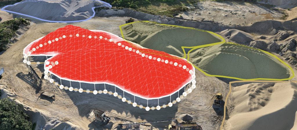
Volumetric Drone Mapping
Know exactly how much material is on your site—no guesswork,
no climbing piles.
Our high-precision drone mapping turns stockpiles of dirt, gravel, sand, or stone into accurate, measurable 3D models. We fly over your site, capture detailed aerial images, and process them into volume reports you can use for:
Inventory audits
Billing reconciliation
Subcontractor verification
Budget tracking
End-of-phase reporting
Deliverables include:
- Material volume reports (cubic yards/meters)
Color-coded 3D site maps
Top-down ortho imagery
Cut/fill comparisons (for before/after scans)
Great for:
Construction yards, quarries, excavation sites, and any team needing clear material tracking.
Progress Monitoring & Ongoing Site Scans
See how your site changes over time—without slowing anything down.
We offer routine flyovers to capture updated data and visuals at weekly, biweekly, or monthly intervals. Whether you’re tracking earthwork, monitoring fill placement, or preparing reports for clients, our scans give you visual and measurable proof of progress.
You’ll know:
How much material was moved
Where site grades have changed
Whether you’re ahead, behind, or right on schedule
Options include:
Ongoing site monitoring programs
Before-and-after comparisons
Progress visuals for clients and stakeholders
Bonus: Our scans reduce the need for your team to physically inspect risky areas—saving time and improving safety.
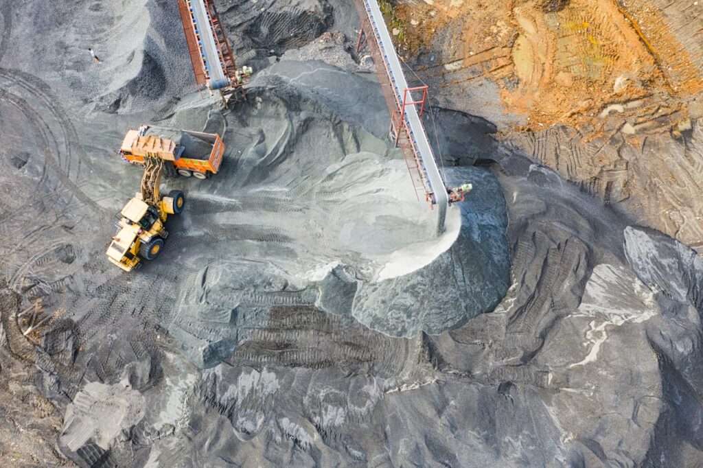
Aerial Photography & 4K Videography
Showcase your site. Document your work. Impress your clients.
Our drones capture high-resolution photos and cinematic 4K video of your site from above. Whether you’re highlighting a finished project, documenting milestones, or creating content for proposals or marketing, we provide visuals that make your work stand out.
We offer:
High-resolution aerial photography (20+ megapixels)
Smooth, cinematic flyovers in 4K video
Drone video for client reports, websites, or social media
Custom shot planning to fit your site layout
Why it matters:
You can use visuals to show stakeholders how much has been completed, attract new clients, or build trust through transparent documentation—without hiring a full video crew.
One-Time or Recurring—You Choose
We make it easy to get what you need without locking you into contracts.
One-Time Scans: Ideal for inventory snapshots, project wrap-ups, or bid documentation.
Recurring Plans: Perfect for active job sites needing regular updates—monthly, biweekly, or based on your schedule.
Every scan is reviewed by our founder and licensed pilot Clint Carter, who ensures quality, accuracy, and clarity with every flight.
Why It Works
- Accurate Measurements – Eliminate overbilling, under-delivery, and guesswork
- Visual Proof – Impress clients and stakeholders with real-time visuals
- Save Time – Faster than ground surveys with less interruption to your workflow
- Improve Safety – Keep your crew off unstable piles or slopes
- Work Smarter – Make better decisions based on real, up-to-date data
FAQ
What types of materials can you measure with drone mapping?
We can accurately measure a wide range of materials commonly found on construction and excavation sites—including dirt, gravel, sand, stone, mulch, and more. If it’s piled or spread on the ground, we can map and calculate it.
How accurate are your volume measurements?
We provide high-precision volumetric data that’s typically accurate within a few percentage points of traditional ground surveys—without the time, cost, or safety risks. Our process is calibrated for consistency and reviewed by a licensed pilot on every job.
Do I need to shut down my site for you to fly?
Nope. Our flyovers are quick and non-intrusive. We work around your active job site safely and efficiently, without disrupting your team or equipment.
What kind of deliverables will I receive?
Depending on your service, you’ll receive:
Volume reports (cubic yards/meters)
3D models of your site or stockpiles
Ortho imagery (top-down stitched aerial view)
High-resolution photos or 4K video
Optional before-and-after comparisons
All files are delivered in easy-to-understand formats you can use for reports, planning, or stakeholder updates.
How soon will I get my results?
Most one-time scans are processed and delivered within 24–48 hours, depending on the size of the site. We’ll give you a clear timeline before we begin, and we pride ourselves on fast, reliable turnarounds.
Do you require long-term contracts?
No. We offer flexible, no-commitment service—whether you need a one-time scan or recurring site monitoring. We’ll work with your schedule and project needs without locking you into anything.
Are you licensed and insured?
Yes. All flights are operated by Clint Carter, a licensed FAA Part 107 drone pilot and manned-aircraft pilot. We carry full liability insurance and follow strict FAA safety protocols on every project.
Can I use your imagery for marketing?
Absolutely. Our photography and video deliver cinematic quality and are perfect for use on your website, social media, or client presentations. Just let us know your goals—we’ll capture what you need.
Let’s Elevate Your Project
Connect with us today for a consultation on how our drone services can support your needs.